


Contact Info
1150 University Avenue
Fairbanks, AK 99709
- Toll-Free:
- 800-437-7021
Basic Directions
Begin your trip at the BLM office in Tok (on East First Street), where you can obtain the latest information on river conditions and advice on trip options. Proceed east from Tok 12 miles on State Highway 2 to Taylor Highway and then to a selected drop-off point, such as the South Fork Bridge Wayside or Fortymile Bridge. Air taxi shuttles to remote drop-off and take-out points can also be arranged in Tok or Fairbanks.
Description
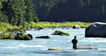
Fortymile River is an extensive network of creeks and rivers in east-central Alaska, 392 miles of which have been given a National Wild and Scenic or Recreational River designation. Boaters have many choices for recreational trips through deep, winding canyons lined by forests of birch, spruce and aspen. Remnants of past mining operations dot the river banks as mementos of the area's rich mining history.